Harry Gwala District Municipality
OVERVIEW
Contact Details
Postal: Private Bag X501, Ixopo, 3276
Physical: 40 Main Street, Ixopo
Tel: 039 834 8700
Fax: 039 834 1701/1750
Web: www.harrygwaladm.gov.za
Geography, History and Economy
Area: 10 547km²
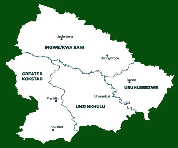
Description: Harry Gwala District Municipality (previously Sisonke District Municipality) is situated south of KwaZulu-Natal. It is comprised of four local municipalities: Ingwe/Kwa Sani, uMzimkhulu, Greater Kokstad and Ubuhlebezwe. The seat of Harry Gwala is Ixopo. The municipality is surrounded by uMgungundlovu to the north-east, Ugu to the south-east, OR Tambo to the south, Alfred Nzo to the south-west, the Kingdom of Lesotho to the north-west and uThukela to the north. It is also bordered by the Drakensberg Mountains, which form a 200km-long World Heritage Site.
Economically, the most prominent employment sectors are agriculture, construction and small-scale manufacturing. The district is known for its progressive farming methods. The unspoilt natural environment has high ecotourism and adventure-tourism potential. Harry Gwala has an abundance of high quality soils, high altitude, abundant water, and climatic extremes, which makes the area suitable for dairy farming. A significant portion of dairy consumed in KZN is produced within the district.
Cities/Towns: Creighton, Himeville, Ixopo, Kokstad, Underberg, uMzimkhulu
Main Economic Sectors: Community services and agriculture (60%)
Local Municipalities:


